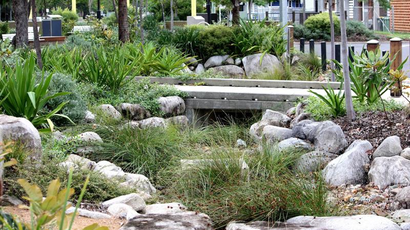
Water sensitive urban design (WSUD)
Design - general
Requirements for the design, manufacture and installation of embellishments
Good design
See the following corporate documents to identify relevant project design requirements:
Sunshine Coast Planning Scheme regulates the way land, buildings and structures are used and developed on the Sunshine Coast.

Sunshine Coast Design contains 10 design principles that guide good project planning and design outcomes, that are appropriate for the Sunshine Coast.
The LIM provides further overarching design advice, refer:
- Introduction and Design Principles - e.g. sustainability, CPTED, accessibility
- Preliminaries - environmental management, tree sensitive design and site set up.
Embellishment requirements
- Universal access.
- Comfortable and suitable for the average person.
- See 'Positioning' and 'Equal access' sections for the corresponding LIM category.
- Made from materials that will be durable and can be suitably protected from exterior elements, such as salt spray and UV exposure.
- Robust and sturdy to withstand constant public use and be resistant to vandalism.
- Fixings are to be 316 marine grade stainless steel (unless otherwise stated).
- Tamper proof fixings should be used
- Graffiti protection coatings applied (where applicable)
- Fire retardant (where applicable).
- Warranties should be as listed below.
- Easily repairable or replaceable.
- Sourced locally and use standard fittings.
- Reputable suppliers should be used who keep a supply of stock parts on hand for the life of the product.
- Use sustainable materials, although sustainability needs to be considered over the lifetime of the embellishment.
- Install on paved, concrete or other hard surfaces (where applicable).
- Manufactured to engineering specifications (where applicable).
- See the 'Standards' section for the corresponding LIM category.
Warranty and asset life
Product/embellishment | Warranty (minimum) | Asset life (typical useful life) |
Open drain (concrete) | 10 years | 70 years 2 |
Open drain (rock-lined) | 10 years | 25 years 2 |
Open drain (earth, vegetated) | N/A | 25 years 2 |
Open drain (canals, revetment walls) | N/A | 50 years 2 |
Overland flow paths, drainage reserves | N/A | 25 years 2 |
Piped network (concrete) | 10 years | 70 years 2 |
Source 2: Sunshine Coast Council Asset Management Plan (figure is based on current data, subject to change).
WSUD
Once the location of the WSUD systems has been decided, based on the Environment and Liveability Strategy (ELS) and Recreation Parks Plan (RPP) guidance, consider the appropriate embellishment level to suit the selected site.
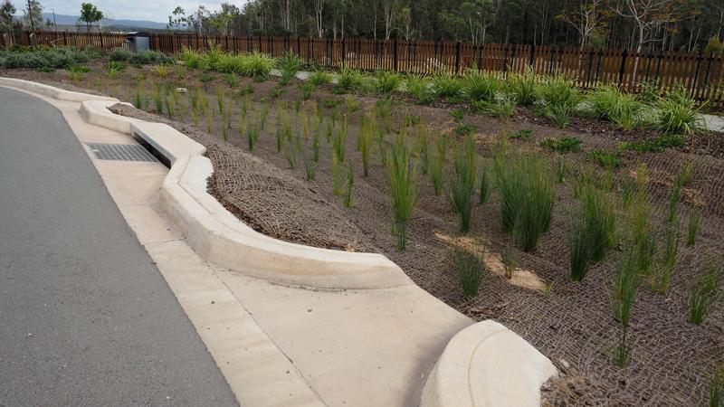
Overarching design considerations:
- Integration of all aspects of the urban water cycle into urban design
- WSUD systems aim to protect the health of aquatic ecosystems and to minimise negative impacts on the natural hydrological cycle
- A combination of treatment systems/levels (a treatment train) can be designed to effectively intercept, moderate and eliminate pollutants from stormwater runoff or groundwater, enhancing and preserving natural waterways while mitigating flood risk and damage to life and property.
WSUD treatment methods
The design of WSUD systems includes the following components displayed in Table 1: Treatment method summary. More detailed breakdown of each is located in LIM WSUD - Design - stormwater management options.
Table 1: Treatment method summary
Treatment method level | Level breakdown | Further guidance |
 | Primary level treatment
| LIM WSUD - Design - stormwater management options - 6.5 Primary level treatments. |
 | Secondary level treatment
| LIM WSUD - Design - stormwater management options - 6.6 Secondary level treatments. |
 | Tertiary level treatment
| LIM WSUD - Design - stormwater management options - 6.7 Tertiary level treatments. |
 | Source control
| LIM WSUD - Design - stormwater management options - 6.8 Source control treatments. |
 | Other systems
| LIM WSUD - Design - stormwater management options - 6.9 Other systems. |
Stormwater drainage design requirements – stormwater quantity
Design of urban drainage systems is to be undertaken in accordance with the Sunshine Coast Planning Scheme Policy for Development Works (PSPDW).
The planning scheme stipulates the outcomes development needs to achieve. It also references the SCC Flooding and Stormwater Management Guidelines and Queensland Urban Drainage Manual (QUDM, IPWEA,2016) The Guideline provide additional information on how to achieve these outcomes. The following is an excerpt from Chapter 4 Stormwater Quantity and Drainage:
"Stormwater quantity management is essential for the protection of people and property and to enhance convenience and amenity during rainfall events".
Engineers/designers calculate stormwater quantities, utilising, among other elements, the following considerations to achieve a water sensitive urban design.
Waterway stability
Defined in PSPDW as limiting the post development peak (63 % AEP = <1yr ARI) event discharge within the receiving waterway, to the pre-development peak 63% AEP discharge (demonstrated through hydrological calculations).
Rainfall intensity
Is to be obtained at the specific location being analysed and is to be in accordance with BoM (Bureau of Meteorology) and ARR (Australian Rainfall and Runoff) recommendations.
- Intensity frequency duration (IFD) estimates are provided by the BoM.
- To account for climate change, adopted current climate rainfall intensities should be increased by 20%.
Rational method
Council have adopted a specific methodology for the Sunshine Coast (Council Rational Method) documented in A Review of Simple Peak Flow Estimation Methods for Use on the Sunshine Coast, following the release of ARR 2016 (Council, 2018a), and is to be used in place of the QUDM rational method:
- For urban drainage design
- To calibrate flood models.
Rainfall temporal (intense burst) patterns
Council has undertaken a review of ARR 2019 Ensemble Temporal Patterns, as documented in Application of Design Temporal Patterns on the Sunshine Coast (SCC, 2018b).
- The document above recommends ARR ensemble patterns for investigations that only require hydrologic modelling (the quantification of flows produced by precipitation).
- For investigations that require hydraulic modelling, MIDIS or MIS single representative patterns are considered appropriate, although a full ensemble approach is not precluded. (A group of rainfall temporal patterns for each event event duration is the basis modelling analysis).
Tail water levels
Tail water levels for HGL (hydraulic grade line) calculations for design of minor/major drainage system are to be based on the requirements of QUDM (IPWEA, 2016) except:
- Tidal conditions are to be increased by 800 mm to account for future sea level rise due to climate change.
- Tail water levels for the design of stormwater quality treatment devices such as bio-retention basins and constructed wetlands are to be in accordance with Table 7 of the Bio-retention Technical Design Guidelines (Water by design, 2014).
Modelling methodology
2d hydraulic modelling in conjunction with unsteady flow hydrology software packages should be considered the default approach to modelling the surface flows component of the major event.
Severe storm assessment
A severe storm assessment is to be undertaken in accordance with the Sunshine Coast Council Flooding and Stormwater Management Guidelines and must seek to ensure that the design does not introduce any new hazardous conditions.
Constructed channels
Vegetated channels (as per Brisbane City Council (BCC) Natural Channel Design Guidelines and Queensland Urban Drainage Manual (QUDM), are the outcome sought by the Sunshine Coast Planning Scheme for new development.
- Open channels should:
- be densely vegetated channels
- avoid the use of concrete or bare rock
- include frequent tree planting to achieve a canopy to shade weeds and reduce water temperatures
- provide adequate access for maintenance.
- Traditional hard lined channels lead to:
- exacerbation of downstream flooding
- increased erosion of downstream soft-lined or natural waterways
- impacts such as increased water temperatures.
- Note that proposals which seek to increase imperviousness in the catchment of high value waterways with low existing imperviousness, will be subject to considerable scrutiny.
See WSUD Appendix A and WSUD Appendix B for further guidance and refer to the relevant authority websites for updated information and current distribution dates for all documents and guidelines mentioned in this category.
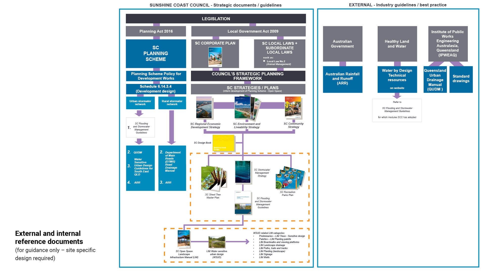
Hierarchy of design guidelines

Note: Read in conjunction with:
- Figure 3: External and internal reference documents
- LIM WSUD - Standards
- Appendix A and Appendix B.
Council guidelines
Council policy documents should be referred to for document relevance and hierarchy, prior to referencing external documents.
Council strategic documents and guidelines include Council requirements for water sensitive urban design.
The appendix contains a list of Council document from which excerpts have been taken. These excerpts are confined to topics that relate to, or have an impact upon WSUD design.
External guidelines
In addition to the above documents, the appendix contains excerpts from external design guidelines, technical resources and tools for industry and council. These excerpts are confined to topics which relate to, or have an impact upon WSUD design.
Figure 3: External and internal reference documents
Coastal hazards
Coastal management, coastal hazard mitigation and climate change adaptation needs to be considered in all current and future planning activities. For WSUD and Open Space Planning these include:
- Managing and protecting dunal areas is a priority outcome
- That constructed assets do not impact upon and are not impacted by natural coastal processes (e.g. the dynamic behaviour of beaches and sand movement, storm tide inundation, salt water intrusion)
- That predicted changes in coastal hazards are considered (e.g. sea level rise, storm tide inundation, open coast erosion and changes in areas of permanent inundation/HAT (highest astronomical tide))
- Incorporating the Council's Coastal Hazard Adaptation Strategy (CHAS), particularly with regard to the adaptation strategies for coastal localities.
- Integrating current and proposed coastal management measures to ensure robust and resilient outcomes.
- Acknowledging and understanding the implications of changes in groundwater levels and salinity to minimise future impacts
See Council's Environment and Liveability Strategy (ELS) for further guidance.
Design team
Integrating appropriate skills and expertise is important for the successful inclusion of WSUD principles and measures in a development.
The WSUD design team must embrace a collaborative approach and all relevant identified disciplines must be included in each project.
Continuity of key design team members input is important for:
- Conceptual design process
- Detailed design stage
- Construction and establishment.
See Table 2: Design field specialist for further guidance.
Table 2: Design field specialist
Design field | Subject | Specialist |
Coastal planning |
| Planning specialist |
Topography |
| Surveyor |
Soils |
| Soil scientist Geotechnical engineer |
Groundwater |
| Environmental engineer/ hydrogeologist |
Ecology |
| Environmental engineer Environmental/ecology specialist |
Land ownership |
| Designer |
Cultural heritage |
| Designer Native Title Claim |
Services |
| Unity Water Energex NBN |
Stormwater management |
| Hydrologic/Hydrotechnical Engineer |
Public safety |
| Designer |
Maintenance access |
| Engineer |
Quality design |
| Designer |
Odour management consultant |
| Engineer |
Infrastructure design |
| Civil/Structural/Environmental engineer (RPEQ qualified) |
Landscape |
| Landscape architect |
Site contamination specialist |
| Engineer |
Environmental management |
| Environmental engineer, Environmental ecology specialist |
This component is currently in development