Paths, trails and tracks

Illustrations
Illustrations of typical path/trail/track classes and samples of possible user groups
Note: Paths/trails/tracks may be comprised of sections with different attributes from a variety of categories such as class 1/2, 2/3, 4/5. The overall class is usually a description of the section of PTT with the highest requirement.
User groups may vary from time to time. Illustrations may not contain a complete range of possible user groups due to drawing size limitations or for the purpose of clarity. User groups detailed in sketches and diagrams are for information only.
Trees and vegetation sketched are for information only and are not intended to indicate a desirable new tree planting outcome. Rather they are indicative of potential mature future tree growth in the years following a path/trail installation.
All paths/trails should be designed to consider equal access to accommodate a wide range of user abilities. Where topography prevents some user access, the path/trail should contain advisory signage.
Offsets shown as dimensions on diagrams and sketches are those required by legislation or are ‘best practice’ design guidelines, operational requirements or Sunshine Coast Council Policy.
Notes shown on sketches are based upon Council minimum requirements for path/trails width and height clearance envelopes, operational requirements and accredited Access Consultant advice.

Class 1 paths provide opportunities for large numbers of visitors, including those with reduced mobility, to undertake walks which have a high level of interpretation and facilities. Paths are designed to allow access by wheelchairs, prams and mobility scooters. They are also designed to accommodate cyclists.
General description:
- Class 1 paths are generally a surfaced path suitable for wheelchairs. They are well maintained with minimal intrusions such as overhanging vegetation.
- Path width varies from 1.2 m to 1.8 m. Wider paths may be considered at high profile/multi user locations.
- Grades are in accordance with the AS 1428 (Set). Steps/stairs are allowed only with alternate ramp access. Tactile indicators may be present along the path/trail.
- Facilities such as car parking, toilets, picnic facilities, litter bins, shelters, seating, viewing platforms and fencing may be encountered along the path.
- Consider existing trees. Consult a qualified arborist regarding setback at paths to larger trees as well as tree protection requirements. Consider alternative alignments if conflicts exist
- All overhanging vegetation – and that which intrudes from the sides into this ‘envelope’ – should be pruned in consultation with a qualified arborist. All pruning targets and cuts should be in-line with AS 4373:2007 Pruning of amenity trees.
- Signage is to include risk, directional, regulation and warning types. Users can expect abundant opportunities to learn about the natural environment through interpretive signs (both on the path/trail and at the path/trail head) or brochures. Include large print, raised tactile and Braille signs.
- For two wheelchairs to pass, a clearance of 1.8 m minimum is required. If such a clearance cannot be maintained, provision must be made for passing bays at regular intervals.
- AS 1428.1 requires the ‘passing space’ or ‘layby area’ for two persons using wheelchairs shall be a minimum width of 1.8 m for a minimum length of 2.0 m.
See Figure 11: Typical elevation – Class 1 high profile path.
Figure 11: Typical elevation – Class 1 high profile path

Class 1 paths are generally a hardened surface suitable for wheelchairs, well maintained with minimal intrusions such as overhanging vegetation.
General description:
- Path width varies from 1.2 m to 1.8 m.
- Consider adjoining land owners (engage the community at design concept stage).
- Consider a wide variety of uses including walking, cycling and wheelchairs, injured and elderly.
- Consider recreation opportunities along the path route.
- Select path route, alignment, grade and surface type to suit expected user groups.
- Consider all permit requirements – Federal, State and Local Government.
- Design offsets as required by Australian Standards for access and mobility (corresponding to the width of path selected).
- Design all other offsets as required for pedestrian and cyclist safety and for vegetation protection and management.
- Ensure offset envelope height is in accordance with the expected user groups.
- Consider Crime Prevention through Environmental Design Guidelines (CPTED) to minimise inappropriate behaviour and minimise public risk.
- For path lighting requirements, see LIM Electrical for further guidance.
- Install embellishments along the path to suit path class and user group expectations.
- Consider existing trees. Consult a qualified arborist regarding setback at paths to larger trees as well as tree protection requirements. Consider alternative alignments if conflicts exist.
- Consult Austroads Guidelines.
See Figure 12: Typical elevation – Class 1 typical path.
Figure 12: Typical elevation – Class 1 typical path
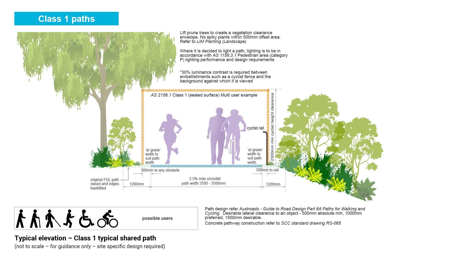
A shared use path is a path/trail that is shared by two users i.e. walkers and cyclists. The path should be designed for wheelchairs, prams, mobility scooters and older people.
General description:
- Class 1 paths are generally a surfaced path suitable for wheelchairs. They are well maintained with minimal intrusions such as overhanging vegetation.
- A path/trail width of 2.5 m (with a clearing envelope of 3.5 m) is suitable for high and medium use paths/trails in urban and near-urban natural areas. This width enables shared use for cyclists, pedestrians, people in wheelchairs and people with prams. A clear height of 2.5 m should be maintained.
- Infrastructure will include seats, viewing platforms, bins, shelters, toilets, car parking, fences and gates.
- All overhanging vegetation – and that which intrudes from the sides into this ‘envelope’ – should be pruned in consultation with a qualified arborist. All pruning targets and cuts should be in-line with AS 4373:2007 Pruning of amenity trees.
- Consider existing trees. Consult a qualified arborist regarding setback at paths to larger trees as well as tree protection requirements. Consider alternative alignments if conflicts exist
- Signage will include interpretive, directional, risk, warning and regulatory signage.
- A barrier fence is required to protect cyclists where there is the following:
- steep batter or large vertical drop in close proximity to the path.
- bridge or culvert on the path.
- hazard adjacent to the path.
- cyclist access to an arterial road requires restricting.
- See the following for further guidance:
- Figure 13: Typical elevation – of Class 1 typical shared path
- Council Standard Drawing PS-010 Bikeway Entrance Control Type – low volume (for bike path entrance to a road reserve).
Figure 13: Typical elevation – Class 1 typical shared path
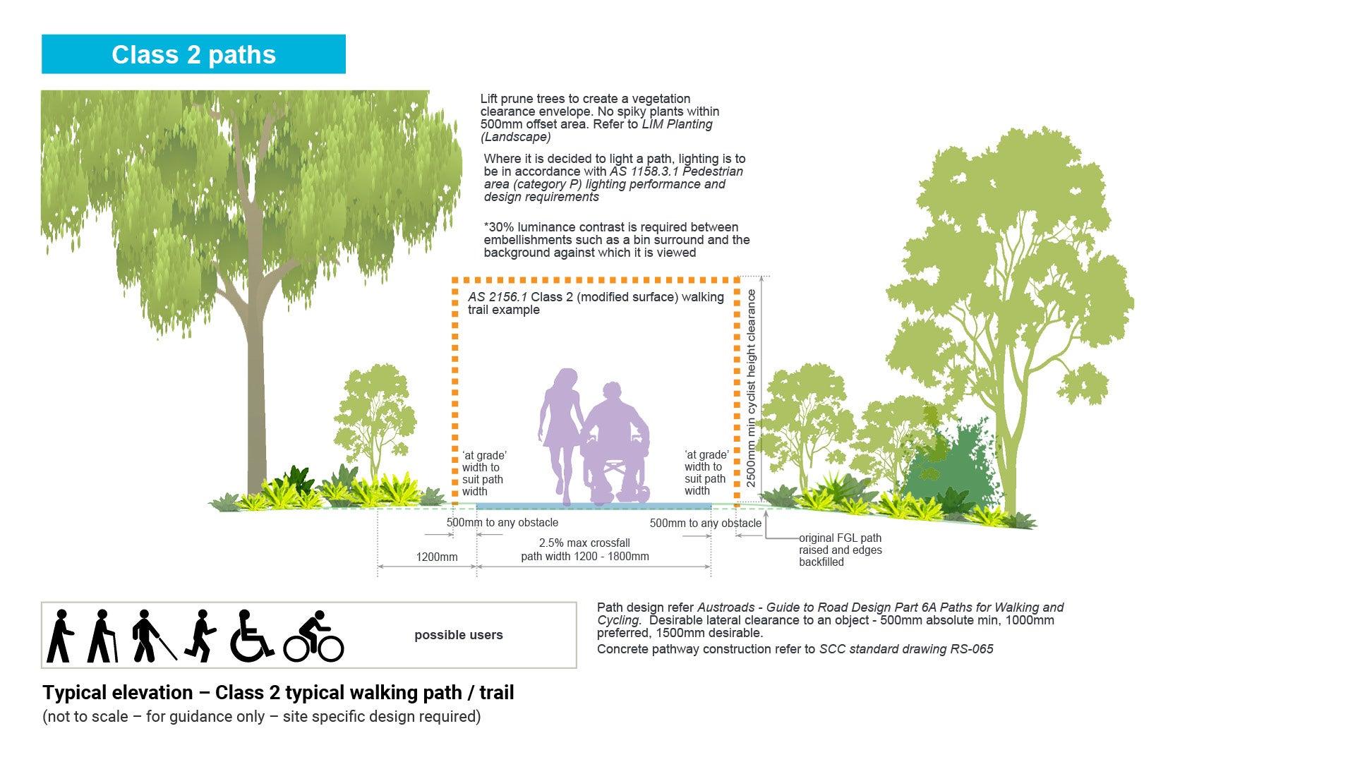
Class 2 paths provide opportunities for large numbers of visitors, including those with reduced mobility, to undertake walks which have a high level of interpretation and facilities. Paths are designed to allow access by wheelchairs, prams and mobility scooters.
General description:
- Class 2 paths are generally a modified or hardened surface suitable for wheelchairs. The path is well maintained with minimal intrusions such as low overhanging vegetation or vegetation growing inside clearance zones.
- Path width varies from 1.2 m to 1.8 m.
- Consider existing trees. Consult a qualified arborist regarding setback at paths to larger trees as well as tree protection requirements. Consider alternative alignments if conflicts exist.
- Locate the path as far from existing native trees as possible.
See Figure 14: Typical elevation – Class 2 typical walking path/trail.
Figure 14: Typical elevation – Class 2 typical walking path/trail

Multi-use path/trails are shared by three (or more) user groups – walkers, cyclists and horse riders.
General description:
- The path/trail width shown will vary depending on use levels and target user experience level. Low use paths/trails should be minimum width 1.5 m while medium and high use paths/trails should be maximum width 2.5 m.
- Cyclists should be warned to not shout or ring their bell and to slow down when approaching a horse.
- ATHRA guidelines – ‘stay out of a horses kicking zone (the rear end of the horse) as it might kick in self-defence if surprised from behind’.
- An alternative path/trail clearing envelope for multi-use paths/trails involves creating a separate and adjacent path/trail for horses. The horse path/trail would be 1.2 m wide (1.5 m at stirrup height) while the path/trail width to cater for shared use between walkers and cyclists will be 1.5 m – 2.5 m depending on path/trail use (See shared use paths/trails).
- A separate path/trail for horses may prevent hoof damage to shared use path/trail surfaces. This approach is best adopted in high and medium use paths/trails, as these are the use levels that justify the additional construction and maintenance costs.
- Infrastructure may include shelters with water tanks, picnic tables, seats, troughs for horses, toilets, car parking accommodating floats, horse day yards, hitching rails, and stiles.
- All overhanging vegetation – and that which intrudes from the sides into this ‘envelope’ – should be pruned in consultation with a qualified arborist. All pruning targets and cuts should be in-line with AS 4373:2007 Pruning of amenity trees.
- Consider existing trees. Consult a qualified arborist regarding setback at paths to larger trees as well as tree protection requirements. Consider alternative alignments if conflicts exist.
- Signage will include directional, risk, and warning signage. On low use paths/trails where there is one clearing envelope, signage should warn users of the narrow path/trail width.
See Figure 15: Typical elevation – Class 2 typical multi-use path.
Figure 15: Typical elevation – Class 2 typical multi-use path
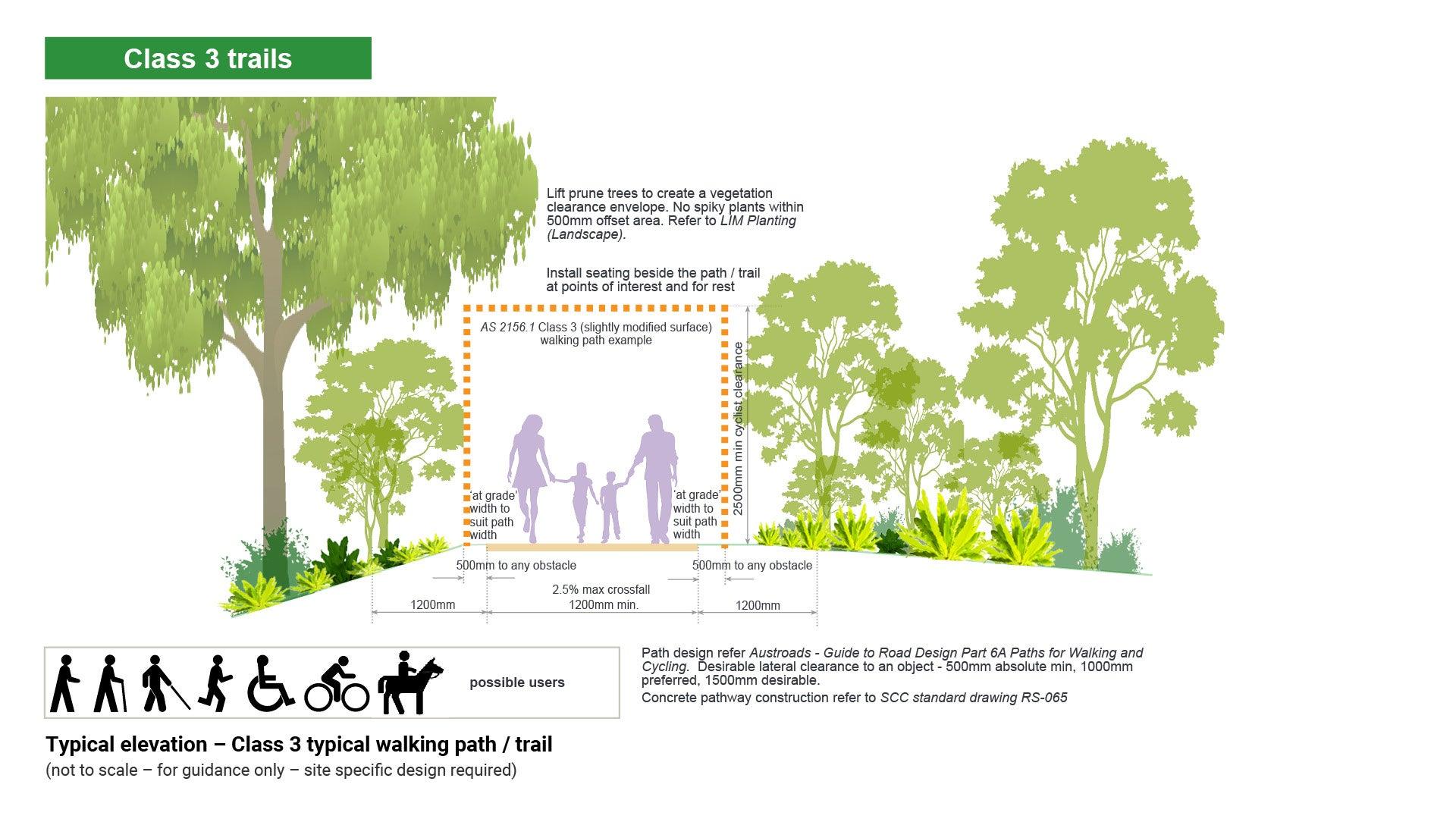
Paths/trails provide opportunities for users to walk in slightly modified natural environments requiring a moderate level of fitness and where the provision of interpretation and facilities is not common.
General description:
- Paths/trails are generally a modified surface. They are kept mostly clear of intrusions and obstacles.
- Minimum width 1.2 m
- Grades may exceed 10% for short sections but are generally no steeper than 10%. Steps may be common.
- Facilities are generally not provided except for specific safety and environmental considerations. Seating may be installed along the path/trail at various points of interest or for rest stops.
- Necessary drainage considerations shall be included in the path/trail design. See LIM Landscape drainage for further guidance.
- All overhanging vegetation – and that which intrudes from the sides into this ‘envelope’ – should be pruned in consultation with a qualified arborist. All pruning targets and cuts should be in-line with AS 4373:2007 Pruning of amenity trees.
- Signage will include risk, warning and directional signage. Users can expect opportunities to observe and appreciate the natural environment with limited or no provision of interpretive signage.
- Where clearance envelopes are unable to be provided due to natural vegetation, consider risk groups such as cyclists.
- Consider installing warning signage at the approach to start and finish of any reduced clearance area.
- Consider existing trees. Consult a qualified arborist regarding setback at paths to larger trees as well as tree protection requirements. Consider alternative alignments if conflicts exist.
See Figure 16: Typical elevation – Class 3 typical walking path/trail.
Figure 16: Typical elevation – Class 3 typical walking path/trail
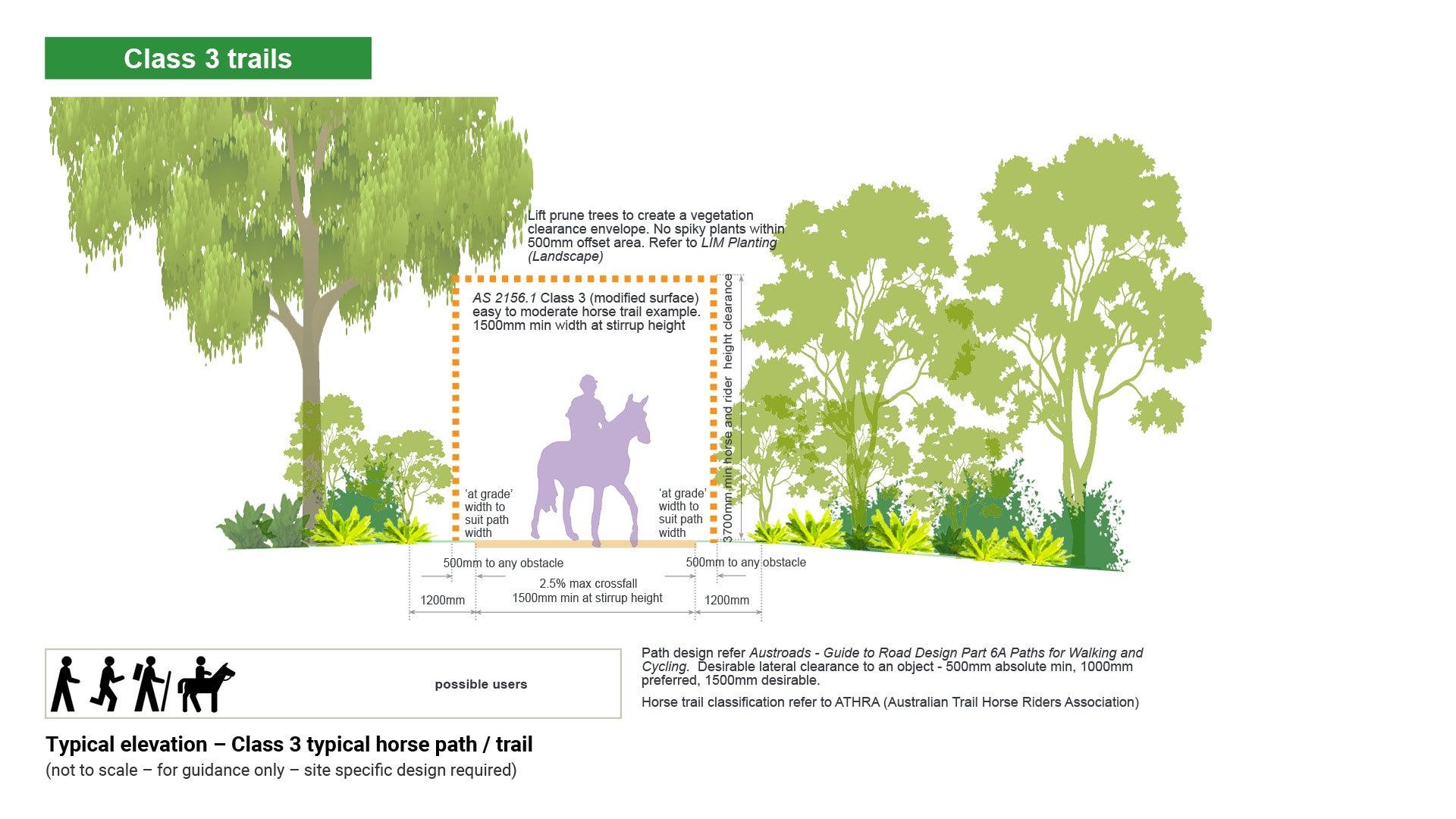
General description:
- Require a moderate level of skill and fitness.
- Surface is slightly modified.
- Path width varies. 1.5 m minimum width is required at horse stirrup height.
- Lift prune trees to 3.7 m (beginner to intermediate horse rider) to create a vegetation clear zone, in consultation with a qualified arborist.
- Path/trail surface should be free of hazards to horse hooves such as glass and loose wire.
- Path/trail surface should be free of ruts or deep potholes which may cause a horse to lose its footing or become trapped.
- As a guide, a horse and rider can traverse slopes that a walker can comfortably walk.
- Horses can step up or down a 500 mm change in level.
- Easy horse path/trail distance ranges from 14 km to 40 km.
- The path/trail is likely to be multi-use.
- Consider existing trees. Consult a qualified arborist regarding setback at paths to larger trees as well as tree protection requirements. Consider alternative alignments if conflicts exist.
See Figure 17: Typical elevation – Class 3 typical horse path/trail.
Figure 17: Typical elevation – Class 3 typical horse path/trail

General description:
- May require a high level of skill, fitness and basic navigation skills.
- Riding experience is essential.
- Surface is distinct and may be variable e.g. some rock and sand.
- Path width varies. 1.5 m minimum width is required at stirrup height.
- Minimum 2.5 m height clearance is required for advanced horse riders.
- Lift prune trees to create a vegetation clear zone, in consultation with a qualified arborist.
- Length of path/trail governs duration and type of ride. Half day and day rides are popular where the destination is a place of interest.
- Path/trail surface should be free of hazards to horse hooves e.g. glass and wire.
- Path/trail may contain challenging sections, steep sections and obstacles.
- Path/trail may be any length and may be in remote areas.
- Consider existing trees. Consult a qualified arborist regarding setback at paths to larger trees as well as tree protection requirements. Consider alternative alignments if conflicts exist.
- Advanced and experienced horse riders require a smaller clearance envelope.
See Figure 18: Typical elevation – Class 4 typical horse path/trail (advanced).
Figure 18: Typical elevation – Class 4 typical horse path/trail (advanced)
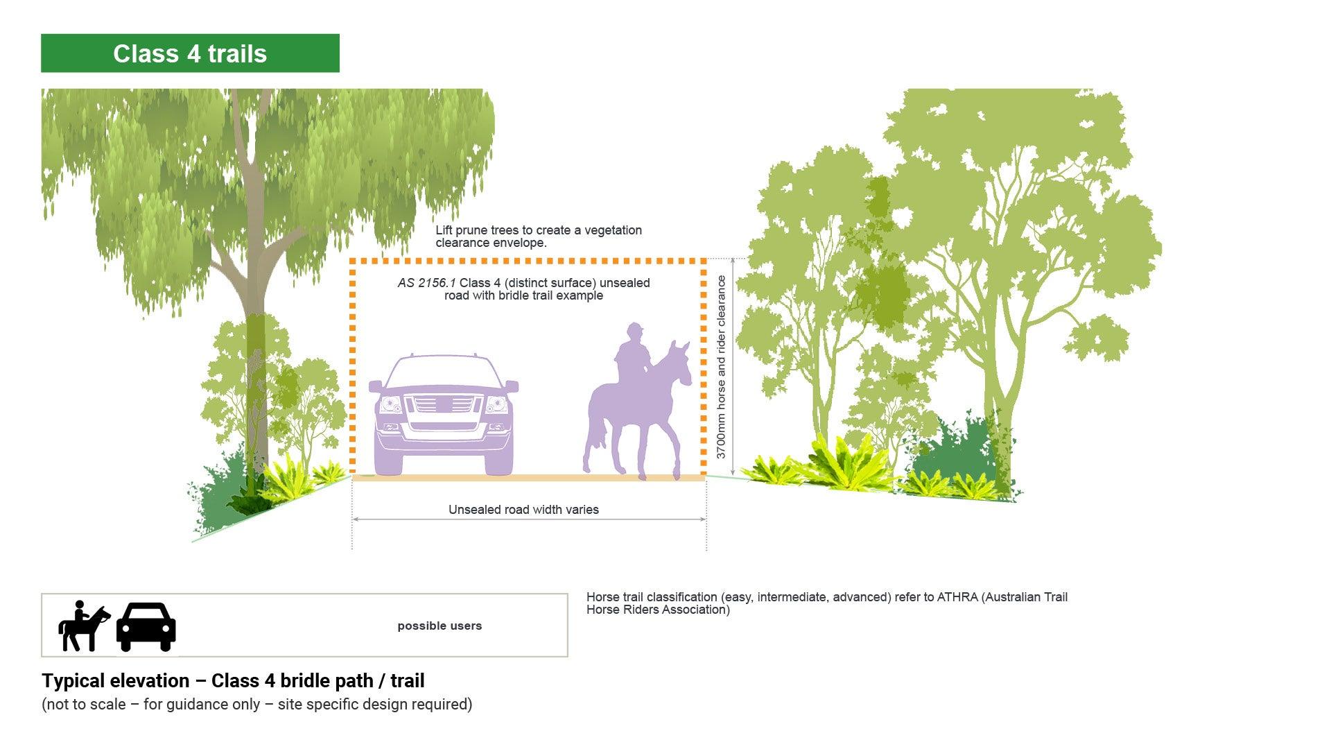
A bridle path/trail is a one way thoroughfare originally made for human transport on horses and may be located on or near an existing gazetted public road. Horse path/trail riders should be able to safely ride to a point where they can access a local path/trail network.
General description:
- The bridle path/trail will require adequate road verge width for a sealed or unsealed road to accommodate a horse and rider while a vehicle passes by (horses can be spooked by vehicles).
- The path/trail should contain minimal pinch points where vehicles and horses may come into conflict. Transport and Main Roads Manual of Uniform Traffic Control Devices Queensland includes warning signage to alert motorists that horses may be present.
- Where the road width is insufficient to accommodate a bridle path/trail on or beside the road, a section of path/trail may require construction within the road reserve area to provide safe traverse for horse and rider.
- Bridle paths/trails through natural areas should be designed to follow the landscape contours avoiding steep terrain where practical.
- Adequate separation distances (vegetation buffer) should be maintained between bridle paths/trails and natural water resources, to minimise the risk of degraded water quality. Bridle paths/trails should not enter waterlogged areas, flowing waterways or wetlands.
- Consider existing trees. Consult an arborist regarding setback at paths to larger trees as well as tree protection requirements. Consider alternative alignments if conflicts exist.
See Figure 19: Typical elevation – Class 4 bridle path/trail.
Figure 19: Typical elevation – Class 4 bridle path/trail

Paths/trails provide opportunities for users to explore and discover relatively undisturbed natural environments along defined and distinct tracks with minimal (if any) facilities.
General description:
- Path width varies. Maximum width 600 mm.
- Paths/trails are generally distinct without major modification to the ground. Encounters with fallen debris and other obstacles are likely.
- Grades are only limited to environmental and maintenance considerations.
- Facilities are generally not provided except for specific safety and environmental considerations.
- Necessary drainage considerations shall be included in the path/trail design.
- Signage will include risk, warning and regulatory signage. Directional signage may be placed at critical locations. Users can expect opportunities to observe and appreciate the natural environment without provision of interpretive signage.
See Figure 20: Typical elevation – Class 4 bush walking path/trail.
Figure 20: Typical elevation – Class 4 bush walking path/trail
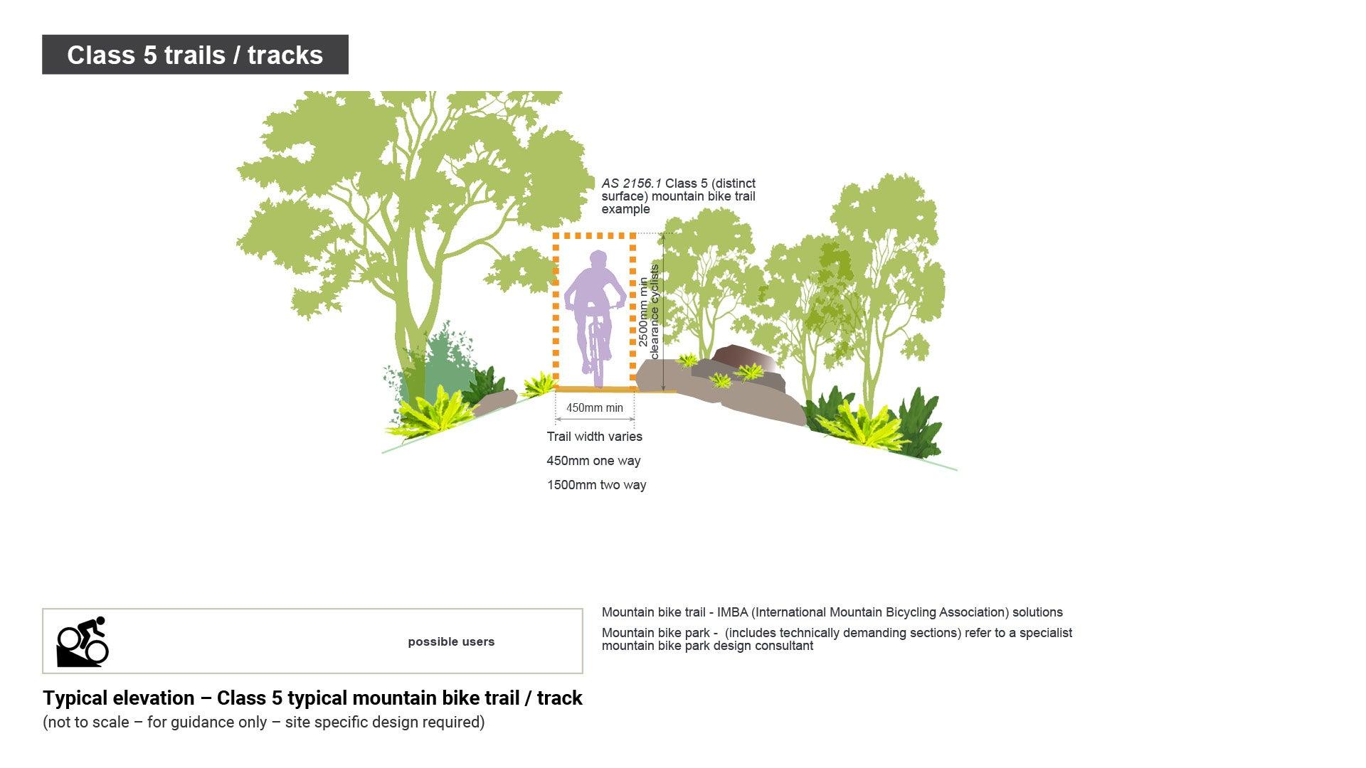
Mountain bike trails/tracks provide an outdoor experience for those who wish to ride mountain bikes in natural surroundings. This guideline deals with building single trails/tracks and two-way trails/tracks for mountain bikes. The primary function is to provide for off road bike use which may include elements that make it technically challenging for any other users.
Mountain bike trails are considered class 5 due to potential hazards, intentionally left in place on the trail/track network to introduce challenge for riders. Potential hazards may include:
- Rocks
- Fallen vegetation
- Natural elements
- Built elements.
This document provides general guidelines only and does not cover the detail of constructing a fit for purpose and technically demanding mountain bike trail. Professional specialist advice should be sought for trails of this nature.
General description:
- Path width varies. Minimum width 450 mm one way, 1.5 m two way.
- Designers/planners of mountain bike trails/tracks should see the International Mountain Bicycling Association (IMBA) ‘Trail Solutions IMBA’s Guide to Building Sweet Single track’.
- Signage will include directional, risk, warning and regulatory. Terrain descriptions and features are important. Users want to know the style of trail/track which may include single trail/track, fire path/trail/track, flowing, jumps, cross country, downhill and technical difficulty. Technically difficult trails/tracks may include steep grades and obstacles requiring technical riding skills, and natural surfaces.
- Single mountain bike trails/tracks tend to wind around and over obstacles such as trees, large rocks, and fallen vegetation. The narrow and frequently challenging nature of these trails demands a constant focus and good speed management. The trail difficulty should be defined by the IMBA guidelines and are rated similarly to ski slopes.
- Trail head parking is the only infrastructure generally provided for local and district level. A regional mountain bike trail head would have a higher level of infrastructure to facilitate events, and a multi-use experience.
- All sustainable development should be well contoured with multiple grade reversals to shed water before it can build up enough to cause erosion or standing water issues.
- Where steep or excessively flat sections of trail/track can not be avoided, engage experienced trail builders to find solutions to potential water problems.
See Figure 21: Typical elevation – Class 5 typical mountain bike trail/track.
Mountain bike trail/track construction guidelines:
Correct trail/track design grades will minimise displacement of materials. Mountain bikers like super-elevation (built up outside edges). Forces at work tend to fling the bicycle out of a corner and so cyclists will naturally take this alignment allowing them to take the corner at high speed. The cyclist is less likely to brake before entering the corner which results in reduced displacement. A good line of sight is essential for mountain bike paths/trails.
Trail/track formation principles:
- Keep water away from the trail/track – maintain cross fall at 3.0% to 4.0%, use a suitable water drainage system, maintain natural waterways.
- Construct sustainable grades – an average trail/track grade of 10% or less is the most sustainable. Gravity and water will move fewer soil particles and visitors will displace less soil.
- Make the track flow – follow the natural contour and avoid straight lines. Make sure the alignment works in both directions.
- Provide a suitable surface – engineering techniques may be required to ensure a firm trail foundation and adequate pavement depth. Care should be taken to use local materials and compact all earthen features at the correct moisture content to ensure their durability and minimise maintenance.
- Design the trail/track according to soil type – soil particle size is the most important factor to indicate the likely behaviour and performance of the facility. Long term performance of construction depends on the soundness of the underlying soils.
- Soil is characterised by its structure which in turn is determined by particle size. Four basic soil types are; clay, silt, sand and gravel. The issue for design and construction is whether the soil will act as a cohesive or granular material.
- Organic material (topsoil) should be removed when constructing a path/trail and stockpiled for landscaping purposes.
- The trail/track surface is distinct, but surroundings are largely natural.
Figure 21: Typical elevation – Class 5 typical mountain bike trail/track
This component is currently in development