Paths, trails and tracks

Fire management
Best practice guidance for integrating fire management access
Note: ‘Fire access trails’ are defined as paths/trails/roads.
Fire access trails
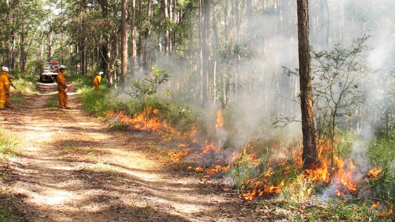
Fire access trails are defined in these standards as those trails which have been constructed for the prime role of fire management using vehicle based suppression techniques or for vehicle based fire management support. These trails may be used for other recreational users such as bush walkers, mountain bike riders or horse riders. These trails are required to be formed, drained, gated and signed. See LIM Signage for further guidance.
Siting guidelines
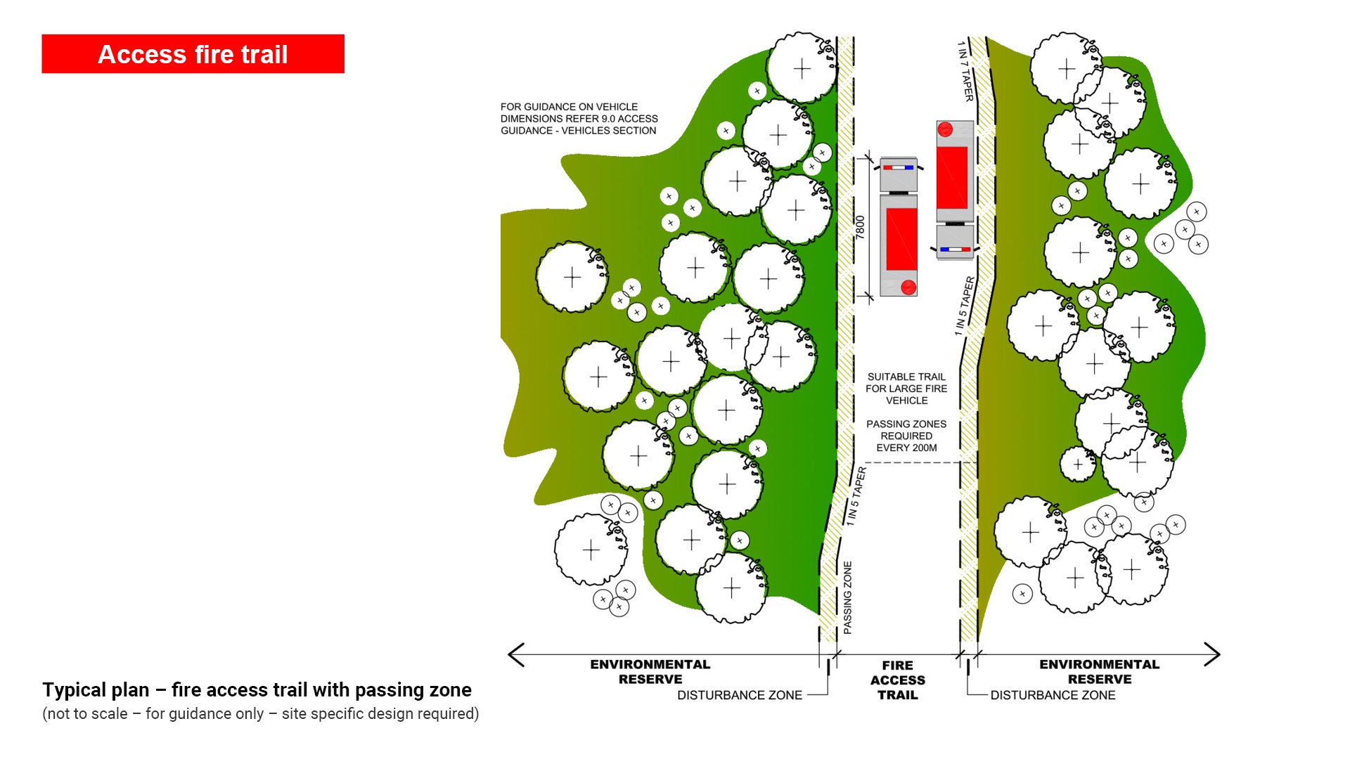
- Where Environmental Reserves (or Amenity Reserves) adjoin residential developments the fire access trails should be located as close as possible to property boundaries to facilitate access for emergency vehicles during wildfire events.
- Within reserves fire access trails should be located so as to provide access and boundaries to distinct fire management units for planned hazard reduction and ecological burns. Landscape features such as ridgelines are used where possible.
Notes
- Where fire access trails are located on slopes, appropriate erosion control devices are required. These can include whoa boys (a small trafficable water diversion bank) or spoon drains with sediment catchment ponds in outflow areas (shallow channels to redirect excess water). The required density of these devices will increase with slope. See LIM Landscape drainage for further guidance.
- Passing bays are required at a minimum of every 200 m along the fire access trail. Turnaround areas are required where through access is not possible.
- Apply road base to the surface of the trail where the natural substrate is erosion prone.
- Specific construction treatments may be required to ensure adjacent trees are not damaged. Council (Parks and Gardens) and Council (Environmental Operations) should be contacted before any existing trees on council-controlled land are pruned or cleared.
- Contractors/plant operators with experience in trail construction and erosion control are required.
See Figure 28 – Typical plan – fire access trail with passing zone.
Figure 28 – Typical plan – fire access trail with passing zone
Types of fire access trails
This section outlines critical design considerations for integrating fire management strategies into path, trail, and track networks, including vehicle clearance requirements, bushfire risk factors, and slope constraints.
Key elements
- Vehicle Clearance: Ensuring sufficient width and structural integrity for emergency and maintenance vehicles.
- Bushfire Risk Considerations: Factors such as vegetation type, proximity to assets, and site-specific hazards.
- Slope: Gradient impacts on fire behaviour, access safety, and erosion control.
See Table 17: Summary - fire access trails.
Table 17: Summary – fire access trails
Fire access trails | Vehicle clearance | Typical key considerations of bushfire risk (may depend on site characteristics) | Slope |
Type 4 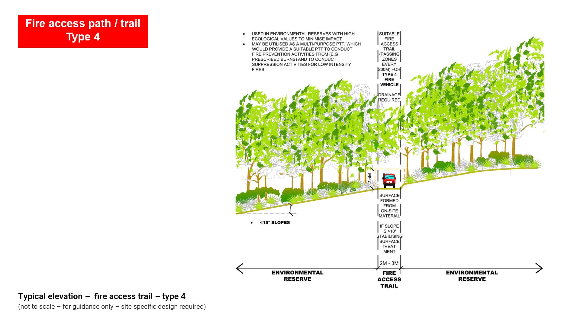 | Small fire vehicle (e.g. 4WD vehicle) Type 4 Vehicle |
| < 15 ° |
Type 5 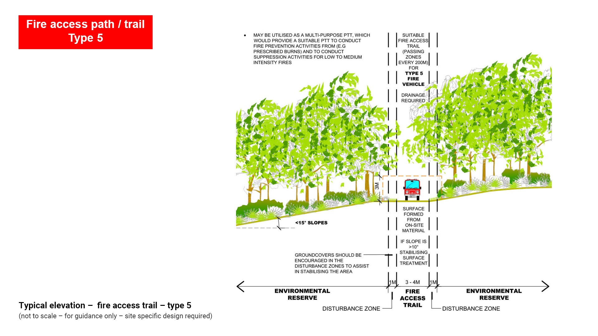 | Medium fire vehicle (e.g. Light to Medium Chassis) Type 5 Vehicle |
| < 15 ° |
Type 6  | Large fire vehicle (e.g. Heavy tanker) Type 6 Vehicle |
| < 5 ° |
Illustrations and explanations

Figure 32: Typical elevation – fire access trail – type 4
Type 4 fire access paths/trails are to be used for:
- Providing access to small fire vehicles (type 4 vehicles) such as 4WD’s.
- May be used as a multi-purpose path/trail/road suitable to conduct fire prevention activities such as prescribed burns and suppression activities for LOW intensity fires.
- Environmental reserves with high ecological values, to minimise environmental impact.
- Slopes less than 15° (steeper slopes would increase construction and maintenance costs).
- Where possible, road design should be constructed as per Austroads Guide to Road Design and Guide to Pavement Technology Part 6: Unsealed pavements.
Type 4 fire access paths/trails are to have the following characteristics:
- Should be 2.0 m to 3.0 m wide.
- Formed from on-site materials, however slopes greater than 10° should include a stabilising surface treatment.
- Passing areas should be provided every 200 m.
- Drainage should be installed along the length and across the fire access path/trail/road.
- In wet areas path/trail/road should be lined with geotextile (grade A34) and covered with clean 75 mm - 150 mm rubble to a minimum depth of 300 mm. The surface should be finished by compacting with a small roller.
See Figure 32: Typical elevation – fire access trail – type 4.

Figure 33: Typical elevation – fire access trail – type 5.
Type 5 fire access paths/trails are to be used for:
- Providing access to medium fire vehicles (type 5 vehicles) such as 3.0 tonne light trucks.
- May be used as a multi-purpose path/trail/road suitable to conduct fire prevention activities such as prescribed burns, and suppression activities for LOW to MEDIUM intensity fires.
- Slopes less than 15° (steeper slopes would increase construction and maintenance costs).
- Where possible, road design should be constructed as per Austroads Guide to Road Design and Guide to Pavement Technology Part 6: Unsealed Pavements.
Type 5 fire access paths/trails are to have the following characteristics:
- Should be 3.0 m - 4.0 m wide with an additional 1.0 m disturbance zone either side (groundcovers should be encouraged to assist in stabilisation).
- Formed from on-site materials, however slopes greater than 10° should include a stabilising surface treatment.
- Passing areas should be provided every 200 m.
- Drainage should be installed along the length and across the fire access path/trail/road.
- In wet areas path/trail/road should be lined with geotextile (grade A34) and covered with clean 75 mm - 150 mm rubble to a minimum depth of 300 mm. The surface should be finished by compacting with a small roller.
See Figure 33: Typical elevation – fire access trail – type 5.
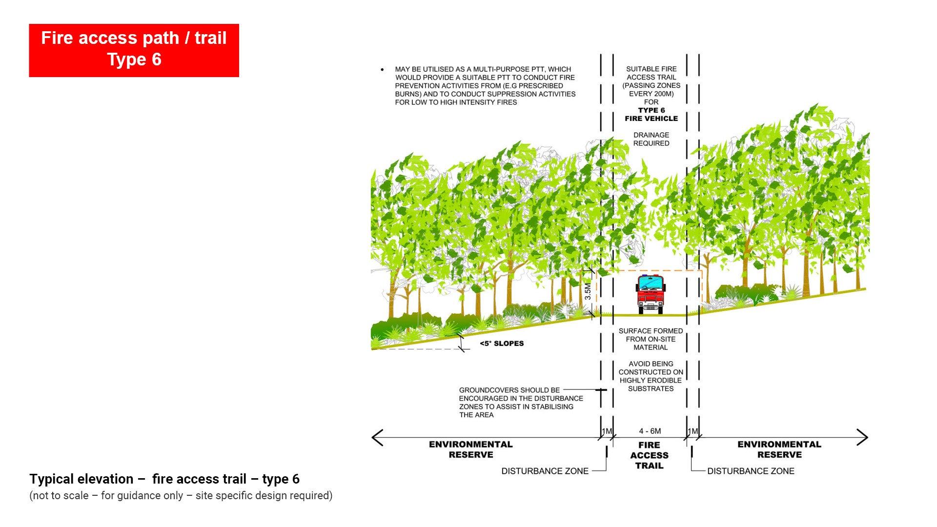
Figure 34: Typical elevation – fire access trail – type 6.
Type 6 fire access paths/trails/roads are to be used for:
- Providing access to large fire vehicles (type 6 vehicles) such as tankers.
- May be used as a multi-purpose path/trail/road suitable to conduct fire prevention activities such as prescribed burns and suppression activities for LOW to HIGH intensity fires.
- Rapid movement of fire appliances to the fire zone.
- Slopes less than 5°.
- Where possible, road design should be constructed as per Austroads Guide to Road Design and Guide to Pavement Technology Part 6: Unsealed pavements.
Type 6 fire access paths/trails are to have the following characteristics:
- Should be 4.0 m to 6.0 m in width with an additional 1.0 m disturbance zone either side (groundcovers should be encouraged to assist in stabilisation).
- Formed from on-site materials, however slopes greater than 10° should include a stabilising surface treatment.
- Passing areas should be provided every 200 m.
- Drainage should be installed along the length and across the fire access path/trail/road.
See Figure 34: Typical elevation – fire access trail – type 6.
This component is currently in development