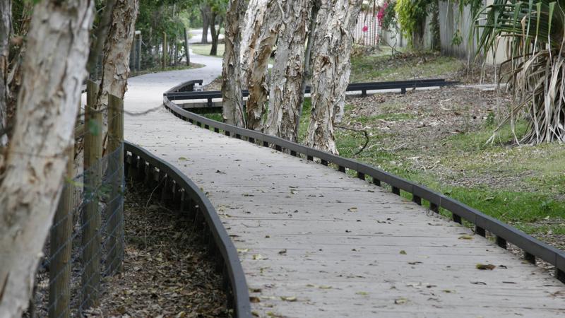
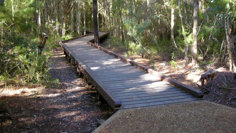
Paths, trails and tracks
Positioning
Best practice guidance for the placement and arrangement of embellishments
Site setout
- Plant trees at time of installation to comply with clearance envelope requirements and for future shade provision.
- Install conduit under pathways at time of construction, for future electrical connection and lighting.
- If pipes and/or conduit are to be installed near a pathway, the preferred location is under the pathway within 500 mm of the edge, parallel to the pathway for maintenance access.
- Install a permanent marker on the path/trail to identify the location of conduit for future location.
- Temporary vehicle crossover for construction purposes.
- Permanent maintenance vehicle crossover.
- Permanent vehicle crossover for recreational vehicles, and emergency vehicles. Consult with Council (Parks and Gardens) to determine the most suitable location for crossover access.
Clearances
Position PTT to provide the following:
- Where sub-base preparation is required within the canopy area of an existing tree, seek tree protection advice from a qualified arborist.
- Lift prune existing trees to create a vegetation clear zone, under the guidance of a qualified arborist.
- Consider mature height and spread of planting so it does not encroach on clearance envelope or require continual high maintenance pruning. See LIM Planting (Landscape) for further guidance.
- Provide an ‘at grade’ area beside the path/trail to prevent a wheelchair from running over the edge of a path or cyclist wheels ‘tramlining’ as per Australian Standards.
- Provide a cyclist run off area as per Austroads Guide to Road Design Part 6A: Paths for walking and cycling.
- Where a runoff area is unable to be provided such as at boardwalks, the Council's Asset Manager is to undertake risk assessment and determine the appropriate action such as realignment or signage.
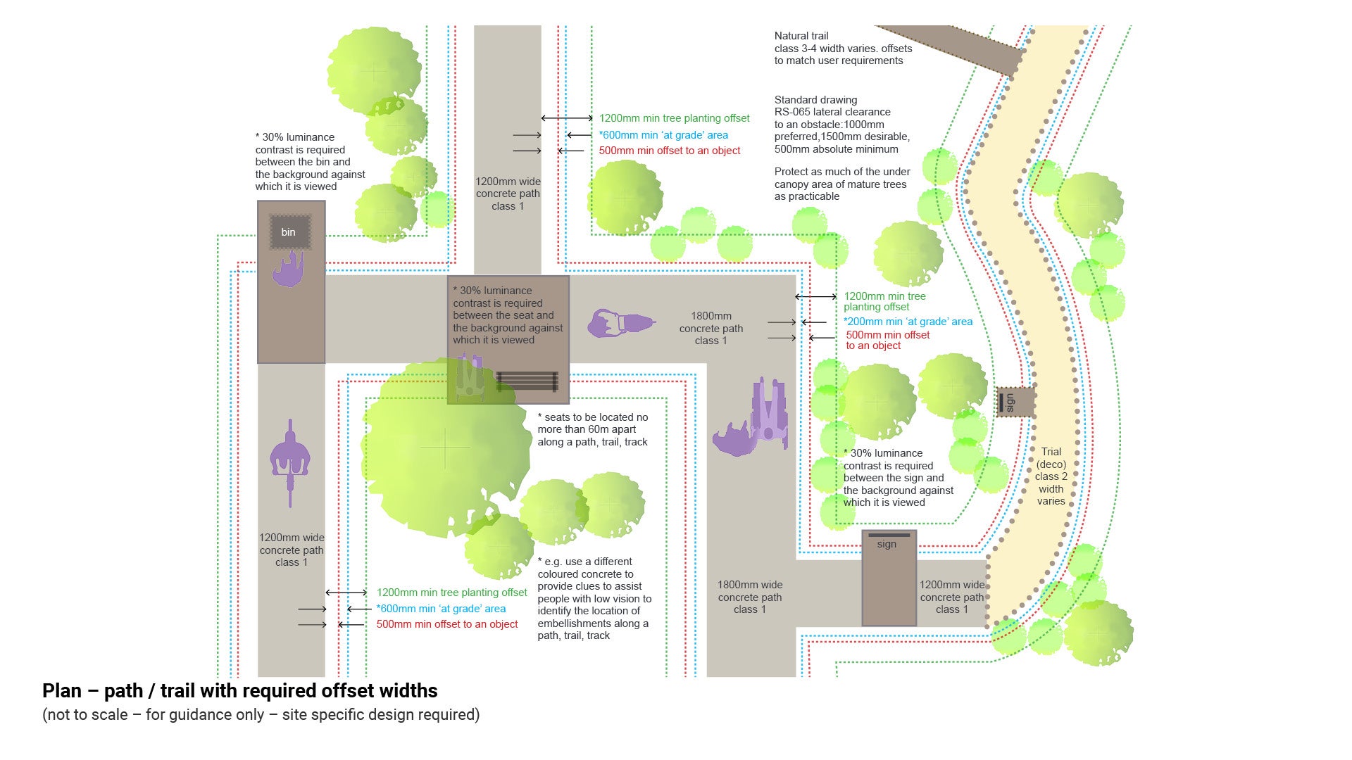
See the following table/figure for further guidance:
- Table 11: Positioning guidance offsets.
- Figure 8: Plan – path/trail with required offsets widths.
Table 11: Positioning guidance offsets
Embellishment | Distance from | Minimum distance | Reason |
Path/trail | Smooth fence | 300 mm | Austroads – for cyclist safety |
Any object e.g. bin | 500 mm | for pedestrian and cyclist safety, comply with Austroads 500 mm min offset from path edge to any obstacle | |
Spiky plants | 500 mm | see LIM Planting (landscape) for further guidance | |
Tree trunk edge | 1.2 m | new tree health safety offset distance. Existing trees offset determined by species in consultation with a qualified arborist. | |
Vegetation | varies according to user group | clearance envelopes (lift prune trees and vegetation) to enhance safety | |
At grade area beside path/trail | varies according to path width | flush transition to reduce path run off hazard | |
edge of path/parallel to pathway edge | within 500 mm | where pipes and/or conduit are to be installed near a pathway, the preferred location is under the pathway for maintenance access | |
other items | 2.5 m | for deck mower clearance (where possible). Avoid creating small difficult to mow areas | |
Seats | Seats | 60 m (max distance) | install seats no more than 60 m apart along the lineal path/trail to create rest intervals as per AS 1428.1. Useful for designs for older people and injured people |
Summary path/trail design clearance widths
- Walkers move anywhere between 5 km/h and 9 km/h while a normally fit person can easily ride at a bicycle speed between 16 km/h and 25 km/h. To create a safe environment for all path users, adequate path width, good sight lines and edge clearances are required.
- Cyclists and walkers can operate right up to the edge of the pavement when passing or overtaking and in this situation their body or bicycle will overhang the edge of the path. When cornering, cyclists may lean up to 25°.
- Safety can be best achieved by adhering to best practice clearance construction guidelines (500 mm Austroads minimum offset).
See Figure 8: Plan – path/trail required offset widths.
Figure 8: Plan – path/trail required offset widths
Clearance areas
Clearance areas are required for the following:
- safety for maintenance personnel
- tree protection
- safety of path/trail users
- equal access.
Overarching offset widths/clearances
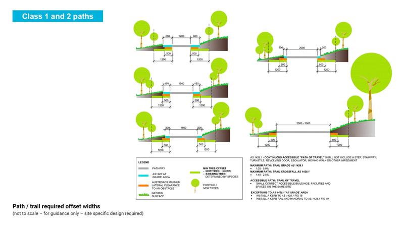
Figure 10: Path/trail required offset widths
Tree planting offset distance
1.2 m edge of pathway to tree trunk. This provision is designed to protect the tree trunk from damage by pedestrian or cyclist impact (which may affect tree health and longevity), as well as protecting cyclists and pedestrians from impact injury.
Existing trees offset distance
- Existing trees can suffer direct construction injury through loss of structural and feeder roots or indirect construction injury via reduced access of roots to water, oxygen, nutrients and growing. space. A qualified arborist can provide specific advice for trees under threat of damage.
- Locate new pathways as far from existing trees as possible as the best protection mechanism.
See LIM Tree sensitive design (existing and new trees).
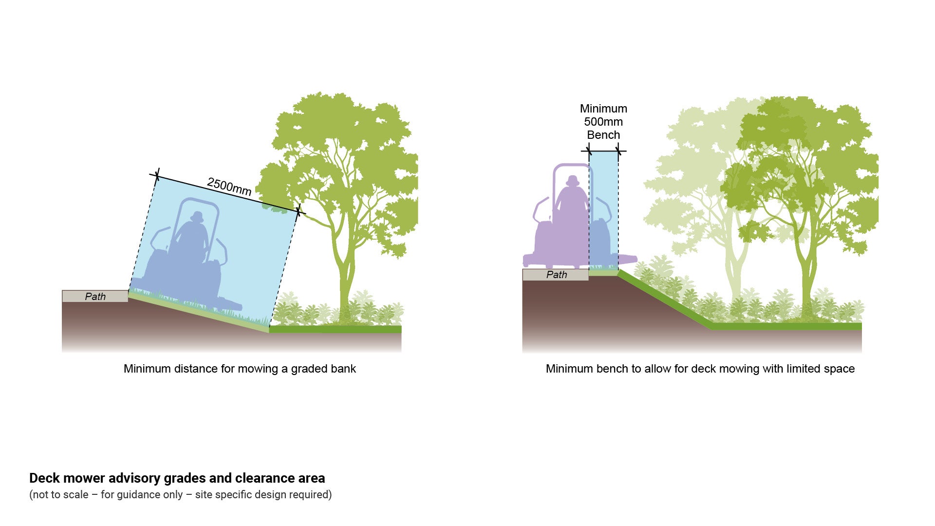
Deck mower clear area and slopes
Where landscaping is provided adjacent to/adjoining drop-offs, slopes over 15 degrees, water, roads, electricity and other critical risks, a risk assessment must be undertaken. The risk assessment must be carried out by a suitably qualified professional, and barriers or other treatments must be provided to mitigate critical risks.
- Avoid the necessity of using push lawn mowers by ensuring sufficient width for a ride-on deck mower to access a turfed area to carry out mowing maintenance.
- Clearance area requirements include provision of sufficient space and room to manoeuvre ride on mowers, with the use of smooth flowing lines to allow machinery to manoeuvre around assets.
- Consider the maximum grade for deck mowers. Turf slopes should be no greater than 15 degrees to allow for safe maintenance.
- Lateral clearances from any obstacles provide safe width for deck mower operation and turning.
- Height clearances provide the deck mower operator with a safe unobstructed operation envelope. Refer to manufacturer specifications.
- To avoid scouring and damaging deck mowers, ensure turf finishes flush with the level height of hardscape infrastructure such as concrete paths.
- 2.5 m clear area is required (where possible) beside a pathway, where a turfed area will require mowing. Deck mowers widths vary (generally 2.0 m wide), chute may fold/remove.
- A flush transition from path surface to turf area may enable a deck mower to undertake edging simultaneously with mowing.
See the following for further guidance:
- Figure 9: Deck mower advisory grades and clearance area.
- LIM Planting (landscape) for guidance on considerations for deck mowers beside pedestrian infrastructure.
Figure 9: Deck mower advisory grades and clearance area
AS 1428.1 ‘at grade’ area beside a path (width required varies with path width)
- This ‘at grade’ is necessary to prevent people who use wheelchairs and mobility devices from running off the path edge and becoming ‘bogged’ in soft ground.
- A small drop off from edge of path to adjoining surfaces means there is potential for a person to be tipped out of a wheelchair, or to become bogged and unable to self-right without assistance.
- This situation has the potential to involve physical injury and loss of dignity for a person needing to request assistance.
- A person who uses a wheelchair could be placed in a vulnerable and potentially dangerous situation, while waiting for assistance.
- A small drop off from edge of path to adjoining surfaces means there is potential for a trip hazard for people with low vision.
See Figure 10: Path/trail required offset widths.
Austroads pedestrian and cyclist paths lateral clearance to an obstacle
- 500 mm minimum, 1.0 m preferred and 1.5 m desirable. This clearance envelope considers the safety of cyclists who are allowed to use pedestrian paths in Queensland
- Cyclists must move over to the left of a path in order to avoid pedestrians and in doing so, have the potential to strike their ankle against obstacles which are too close to the path edge, or contact an obstacle with the bicycle pedals and risk a fall.
See Figure 10: Path/trail required offset widths.
Path width and permeability
Carefully consider competing requirements between universal access and the minimisation of environmental impacts when determining the width and material for a pathway.
Path width
Table 12: Path width/AS 1428 requirements
Path, trails and tracks - Width | Possible application | AS 1428 requirements |
1.2 m |
|
|
1.5 m |
|
|
1.8 m |
|
|
2.0 m |
|
|
over 2.0 m |
|
|
CAPT - continuous accessible path of travel as defined in AS 1428.1 – no at grade section required where path widths exceed 2.4 metres, or change the width description to over 2.4 m
DOL - Dog off leash area
Permeable path materials
Permeability is the property of the soil to transmit water and air to supply root-zone air, moisture and nutrients for plant uptake.
- Permeable pavement such as decomposed granite and permeable concrete grid paving, allow water to seep through voids into the ground to benefit plant life.
- Balance the requirements and factors which effect the natural environment with the needs of people for connection.
- At low use locations, consider that a narrow path may provide for user needs.
- Follow water sensitive design principles. This design approach integrates the urban water cycle into urban design to minimise environmental degradation.
- Sections of porous paving can be used in conjunction with non-porous paving to allow infiltration in specific areas of need.
- See LIM Water sensitive urban design (WSUD) for further guidance.
Non-permeable path materials
Non-permeable path materials such as concrete and asphalt reduce the air, moisture and nutrients available to plant life.
- Consider the requirement for hard surfaced pathways to connect and allow universal access and movement between urban facilities and embellishments.
- At high use play spaces, consider the needs of parents/carers with prams, children and adults who use wheelchairs, people with low vision and older people. A wider path enables universal access.
- At high use recreational locations such as beach-side, consider pathways which meet the needs of a wide variety of abilities.
Grades
The design of path/trail grades should consider the natural surface grades, as well as the user requirements.
Natural surface grade
Natural grade is one of the primary factors which influence path/trail design. Path/trail grades should be selected to minimise the risk of erosion which in turn influences the frequency of maintenance.
- Gentle grades are preferable and provide acceptable and safe use for a wide variety of path/trail users. Gentle grades reduce the need for erosion control measures.
- Long sections of uniform grade should be avoided. Grades should undulate gently to provide natural drainage and to provide relief between steeper climbs.
- Grades can be expressed as a ratio of vertical to horizontal distance (rise to run) such as 1:10 or (10%).
- Low grades lead to poor drainage.
- It is preferable that grades do not exceed 10%. However, in some instances it is unavoidable due to the nature of the terrain or designated location of the path/trail such as in road reserve.
- The presence of larger trees may trigger the need to build an ‘above grade’ or elevated path
- Consider the protection of existing trees. Consult a qualified arborist.
See Table 13: Grade degrees, percentage and rise to run.
Table 13: Grade degrees, percentage and rise to run
Degrees | Percentage | Rise to run |
1 | 1.7 | 1:57.3 |
2 | 3.5 | 1:28.6 |
3 | 5.3 | 1:19.1 |
4 | 7.0 | 1:14.3 |
5 | 8.7 | 1:11.3 |
6 | 10.5 | 1:10.5 |
7 | 12.3 | 1:8.2 |
8 | 14.0 | 1:7.1 |
9 | 15.8 | 1:6.3 |
10 | 17.6 | 1:5.7 |
11 | 19.4 | 1:5.1 |
12 | 21.3 | 1:4.7 |
13 | 23.1 | 1:4.3 |
14 | 25.0 | 1:4 |
15 | 26.8 | 1:3.7 |
16 | 28.7 | 1:3.5 |
17 | 30.6 | 1:3.3 |
18 | 32.5 | 1:3.1 |
19 | 34.4 | 1:2.9 |
20 | 36.4 | 1:2.7 |
21 | 38.4 | 1:2.6 |
22 | 40.4 | 1:2.5 |
23 | 42.5 | 1:2.4 |
24 | 44.5 | 1:2.2 |
25 | 46.6 | 1:2.1 |
User type recommended grades
- The following table provides design development guidance which considers various user requirements, dependent upon path/trail classification.
See Table 14: Path/trail grade, width and clearance.
Table 14: Path/trail grade, width and clearance
Class | Path/trail user | Min/max grade | Path/trail width (min/max) | Path/trail height clearance (min/max) |
Class 1/Class 2 | Walk | <5% to <15% | 1.2 m - 1.8 m | 2.4 m - 2.5 m |
Cycle | Max 10% | 1.5 m - 3.0 m | 2.5 m | |
Horse | Max 10% | 1.5 m - 3.0 m | 2.5 m - 3.7 m | |
Class 2/Class 3 | Walk | <10% to 25% | 1.2 m - 1.8 m | 2.4 m - 2.5 m |
Cycle | Max 15% | 1.5 m - 3.0 m | 2.5 m | |
Horse | Max 15% | 1.5 m - 3.0 m | 2.5 m - 3.7 m | |
Walk / Cycle | <5% to <15% | 1.5 m - 3.0 m | 2.5 m - 3.7 m | |
Cycle / Horse | <5% to <15% | 2.0 m - 4.0 m | 2.5 m - 3.7 m | |
Class 3/Class 4/Class 5 | Walk | <15% to 30% | 500 mm - 600 mm | 2.4 m - 2.5 m |
Cycle | Max 20% | 1.5 m - 3.0 m | 2.5 m | |
Horse | Max 20% | 1.5 m - 3.0 m | 2.5 m - 3.7 m |
Strategic documents recommended grades
The following table provides design development guidance which considers various user requirements, dependent upon path/trail degree of difficulty. Difficulty level is as classified by:
- peak user body.
- internationally recognised best practice guidelines.
- Queensland guidelines.
See Table 15: Summary of path/trail user and design guidelines.
Table 15: Summary of path/trail user and design guidelines
Organisation | Easy | Moderate | Advanced |
Australian path/trail Horse Riders Association (ATHRA) | 10% Max | 15% Max | 20% Max |
US Forest Service (Walking) | 5-20% up to 30 m | <12-30% up to 100 m | <18-30% up to 100 m |
US Forest Service (Horse Riding) | <5-15% up to 70 m | <10-25% up to 100 m | <15-30% up to 150 m |
US Forest Service (Multi Use) | <5-15% up to 70 m | <10-25% up to 100 m | <5-30% up to 150 m |
US Forest Service (Mountain Bikes) | <5-10% up to 30 m | <10-30% up to 100 m | <15-30% up to 150 m |
Draft SEQ Active trails implementation guideline | <5-15% up to 100 m | <10-25% up to 125 m | <15-30% up to 200 m |
Path/trail classification based on AS 2156.1 – Walking Tracks – classification and signage directs construction.
This component is currently in development