Overarching guidelines

Design
Requirements for the design, manufacture and installation of embellishments
Good design
See the following corporate documents to identify relevant project design requirements:

Sunshine Coast Planning Scheme regulates the way land, buildings and structures are used and developed on the Sunshine Coast.

Sunshine Coast Design contains 10 design principles that guide good project planning and design outcomes, that are appropriate for the Sunshine Coast.

The LIM provides further overarching design advice, refer:
- Introduction and Design Principles - e.g. sustainability, CPTED, accessibility
- Preliminaries - environmental management, tree sensitive design and site set up.
Embellishment requirements
- Universal access.
- Comfortable and suitable for the average person.
- See 'Positioning' and 'Equal access' sections for the corresponding LIM category.
- Made from materials that will be durable and can be suitably protected from exterior elements, such as salt spray and UV exposure.
- Robust and sturdy to withstand constant public use and be resistant to vandalism.
- Fixings are to be 316 marine grade stainless steel (unless otherwise stated).
- Tamper proof fixings should be used
- Graffiti protection coatings applied (where applicable)
- Fire retardant (where applicable).
- Warranties should be as listed below.
- Easily repairable or replaceable.
- Sourced locally and use standard fittings.
- Reputable suppliers should be used who keep a supply of stock parts on hand for the life of the product.
- Use sustainable materials, although sustainability needs to be considered over the lifetime of the embellishment.
- Install on paved, concrete or other hard surfaces (where applicable).
- Manufactured to engineering specifications (where applicable).
- See the 'Standards' section for the corresponding LIM category.
Warranty and asset life
Product/embellishment | Warranty (minimum) | Asset life (typical useful life) |
Sign type - park naming | 2 years | 10 years 1 |
Sign type - interpretive | 2 years | 10 years 1 |
Sign type - directional | 2 years | 10 years 1 |
Sign type - regulatory | 2 years | 10 years 1 |
Sign type - sign board | 10 years | 10 years 1 |
Sign type - water marker | 1 year | 10 years 1 |
Aluminium sign panel | 5 years | 10 years 1 |
Aluminium sign frame/posts | 5 years | 10 years 1 |
Galvanised posts | 10 years | 10 years 1 |
Tea staining prevention application for SS | 5 years | N/A |
Source 2: Sunshine Coast Council Asset Management Plan 2017/18-2022/23 – Parks and Gardens (figure based on current data, subject to change).
Signage
Once the location of the signage has been decided, based on the Environment and Liveability Strategy (ELS) and Recreation Parks Plan (RPP) guidance, consider the appropriate embellishment level to suit the selected site.
Overarching design considerations:
All open spaces should include universal access (e.g. place sign at legible heights for all users to access, position signs for the desired user to access).
Designing successful signs

Positive outcomes
Signage should provide one or more of the following outcomes:
- Create a safer place. Clear and precise signing is proven to decrease potential risk to visitors.
- Create an experience. Provide a recreational or educational experience for visitors by providing relevant information.
- Improves recreational access and responsible visitor behaviour.
- Increases visitor understanding of the local environment, equipment and local flora and fauna.
- Promotes an area's history, flora and fauna, local cultural and natural heritage.
- Displays clear information by the content including the following, to inform and instruct park users:
- the ability to report faults or damage that may otherwise go unreported, or may potentially cause injury or further damage to equipment.
- park or reserve name and location to aid emergency services.
- Ensuring the content displays sensitive and appropriate messages in a local setting.
Characteristics
Signs should be:
- Attractive and informative with text and graphic elements that will be visually interesting to the viewer.
- Notable and recognised to suit the intended purpose.
- Simple to follow and understand.
- Related sympathetically to the environment.
- Compliant with any relevant standards and requirements (such as playground and exercise equipment standards).
Deciding what signs are required
To decide on a sign or a family of signs, you must first determine the following:
- Geographical scope of the area and park hierarchy - for example, is the site, a streetscapes, a local park, or an environmental reserve.
- Type of sign suite required - survey the variety of open space activities carried out in the area.
- Single/multiple signs - does the project require a family of signs or a single sign (such as a single entrance sign or an entrance sign supported with other signs within the site).
- Target audience and viewing height - what distance and height will the sign be viewed from (such as at pedestrian or motor vehicle level).
- Type of sign message - what is the broader message you are trying to convey (such as regulatory, information, warning).
- Purpose, theme and activity - who are you targeting the sign towards. For example, a playground activity entry sign is intended to provide safety content to parents and carers.
- Sign content - what message needs to be conveyed to the users.
- Location and orientation - this is site specific and must be carefully considered.
- Location of asset - determine which sign suite the sign/s will be selected from.
- Existing signs - do any existing signs require replacing. Can existing information be incorporated into new signs.
- New signs - are any other new signs required.
Key positioning points
Signs are useful at:
- Arrival points – where people join a pedestrian network, or enter open spaces.
- Decision points – where people arrive at a point of choice where they are required to select a direction of travel.
- Key destinations within open space areas – public transport stops, tourist attractions and community facilities.
- Places of options or unclear routes – locations where there is ambiguity in the route, such as major junctions and large open areas.
- Between destinations – there may be a considerable distance between destinations. A sign can reinforce the correct route is being travelled.
Where a destination is signed at the beginning of an open space area, direction signs at every decision point are required until the destination is reached.
Site risk assessment
A site risk assessment should be undertaken prior to installing any sign, to ensure best practise positioning. The following must be considered:
- Consider upgrading or repairing areas that require on-going maintenance.
- Installation of signs should be kept to a minimum to avoid visual clutter and potential confusion for park users.
- Consider removing multiple existing signs and replacing with a single sign, where it is appropriate.
- Consider best practise locations for the installation of all signs (refer to positioning guidance).
Equal access wayfinding markers

The AS 1428.4.2:2018 Design for access and mobility Part 4.2: Wayfinding signs. The equal access wayfinding signs included in the LIM Signage suite have been developed in response to this standard.
Purpose
Equal access wayfinding markers in the context of the Open Space Landscape Infrastructure Manual (LIM), are used to identify equal access arrival points for pedestrians within open spaces, to assist in identifying key destinations. The markers focuses on arrival, directions and destination communication, for Vision Impaired People (VIP); people with low vision and people who are blind.
They also contain raised tactile text and or pictograms and may include equivalent information in Unified English Braille Code (UEBC) Grade 1. Braille should only be incorporated into the sign panel, where the immediate area is deemed safe for a blind person to navigate.
Equal Access Wayfinding signage does not include prohibition, warning and education signs.
When are they required and why?
The Sunshine Coast Council strives to be a leader in providing facilities for the enjoyment of everyone.
New technologies are continually developing, however raised tactile and the Unified English Braille Code (UEBC) Grade 1 remains a key communication tool for people who are blind and for people with low vision.
In addition to signs mounted at heights to be read by a person seated in a wheelchair, open spaces may require a wayfinding sign specifically designed for people who are blind or have low vision. Signs that feature raised tactile and Braille are Wayfinding equal access markers.
Application of Wayfinding equal access markers
Wayfinding equal access markers are designed to compliment an existing or proposed entry sign or as a stand-alone sign. Signs that have been designed to compliment the marker are:
- Pedestrian entry sign
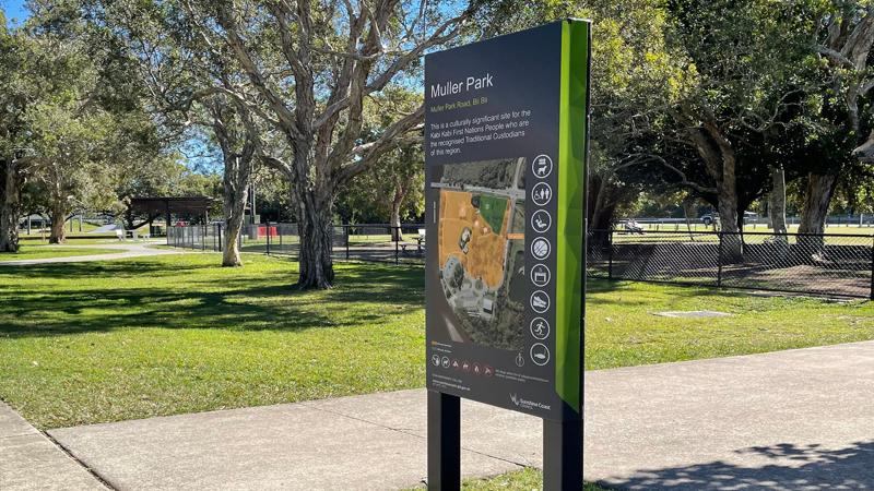
- Map and information sign.
Wayfinding equal access markers complement standard signs. The aim is for people with low vision and people who are blind to become accustomed to the marker location. Familiarity will aid navigation of other parks and reserves that apply the same treatment. Wayfinding equal access markers are to be installed as follows:
- The marker must be installed to the right of a sign, with a minimum offset of 200 mm from an entry sign.
- For new pathways, a luminance contrast treatment is recommended to form the sign slab, and must be the full width of the path of travel. This treatment creates a visual and physical cue to the location of an accessible sign.
- Markers should be installed at entries to open spaces which contain a continuous accessible path of travel to a destination, such as amenities or seat.
Every item on a marker is to include raised tactile elements, and where possible, Unified English Braille Code (UEBC) Grade 1, underneath the raised characters or pictograms. The markers are to contain basic information such as the location name and important destinations such as: amenities, information centre, library.
Note: UEBC should only be used if the site, or part there of, is deemed safe to navigate for people who are blind.
Wayfinding equal access markers should be considered on a case by case basis. Where there is no continuous accessible path of travel and no destination, they should not be installed.
Typical examples of where the markers are not required:
- A local park, as they typically do not include pathways or accessible toilets. Vision Impaired People (VIP) will already be familiar with their local area.
- Grade three and four trail networks. These trails are not accessible for VIP. The trails typically contain uneven surfaces, narrow sections, steps and steep climbs.
Sign development and installation

This section outlines the procedures for assessing, removing, and upgrading existing signage, recording GPS locations, and implementing new sign installations in accordance with Council standards.
Staging removal of existing signs
Sign assessment must be undertaken to identify and mark existing signs prior to removal. Assessment will identify all signage to be removed.
Staged removal of signs, particularly public warning signs, should be undertaken with care to ensure public safety is not endangered.
Where existing signs have the potential for improvement, this is the opportune time to carry out upgrades.
Before installation, consider the following:
- Is the existing sign in the best location.
- Does the sign require double sided viewing.
- Does the existing sign adhere to current requirements and standards.
- Is the existing sign legible. Positioned at the optimum viewing height.
- Is the message conveyed clearly.
- Does the message use a positive tone. Signs using a positive tone are more likely be read and adhered to.
- Initial removal should include any non-standard signs within close proximity to a new Council sign, or where a sign has been overgrown for a long period of time.
- Ensure there is no lag between removal and replacement of existing signage.
GPS locations for signs and access points
A Global Positioning System (GPS) is a radio navigation system that enable users (land, sea and airborne) to determine the exact location of an object by using co-ordinates specific to the location of that object.
It is a Council requirement that all new signs installed have their GPS location recorded. The location is mapped and that data is provided to Council Geospatial Data team for collation into data records and for use in the field by maintenance and operations teams.
It is recommended that signs, such as entry point sign locations, are shared with local Emergency Services for enhanced public safety.
Where existing signs are decommissioned or removed, the sign data must be removed from the Council Geospatial database.
Development and implementation
The process of developing and implementing a sign project may involve the following stages:
- Develop a sign strategy to determine type(s) of sign, site requirements, existing guidelines to reference and budget.
- Design the sign in line with the applicable Council guidelines and standards. See below for list.
- Manufacture and installation of the sign(s).
- Sign location mapped and provided to Council Geospatial Data team.
First Nations people acknowledgement
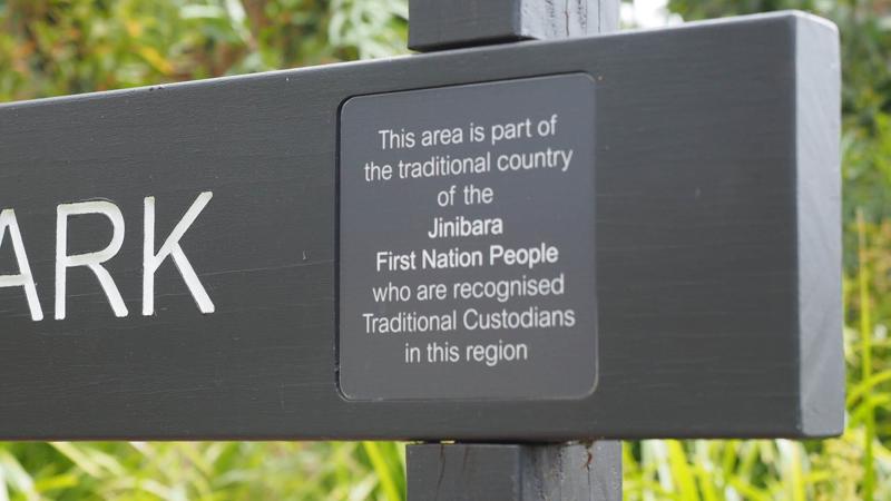
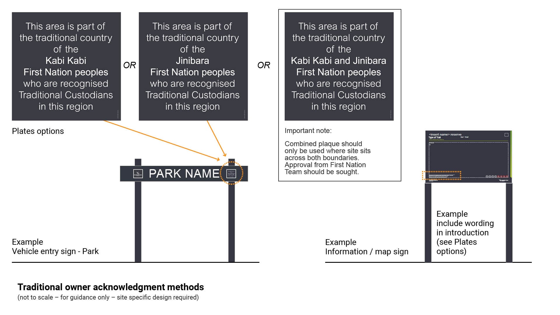
Council acknowledges the traditional owners and recognise the continuing connection of Aboriginal traditional owners in the region. All wording has been approved and must not be altered unless otherwise approved by all stakeholders.
Entry signs require this acknowledgement. See Figure 1: Traditional owner acknowledgement methods. It is achieved differently depending on the type of sign, using three wording choices:
- Vehicle entry sign – plate fixed to sign
- Map and information sign options.
Determine suitability
All acknowledgements must be approved prior to use on any sign to ensure correct application. Council (Economic and Community Development) determine and approve First Nations people acknowledgements.
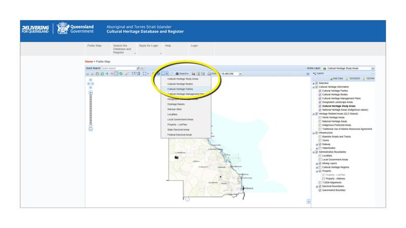
To determine the First Nation Party on whose land a sign will sit, visit the Cultural heritage database. (Ensure 'Map Tips' dropdown has Cultural Heritage Parties checked).
Figure 1: Traditional owner acknowledgement methods
Core elements of signage design

This section defines the essential graphic standards and specifications for signage design, including language requirements, copyright and legal compliance, photographic and illustrative elements, pictogram integration, colour application, text sizing and spacing, approved font usage, and map implementation.
Overarching principles
Elements to consider to create a successful message:
- Keep the sign simple. Provide adequate space around items (often referred to as 'white space').
- Content should be succinct and direct with a positive message.
- Pictograms should be used to support information, or separately to create a quick message.
- Sign design and layout should consider additional/alternative methods of communicating information, rather than written text, such as:
- Pictograms.
- Photographs/illustrations
- Large print.
- Raised tactile and Unified English Braille Code (UEBC) Grade 1.
- Audible format.
- Where possible, use the largest specified text size for estimated viewing distances. If the text is too small, the sign will not be read.
Language and graphic components
The language used for all signs will be English. Although the Sunshine Coast is visited by a large number of international tourists, the use of multi-lingual signs is not recommended. The most effective way to communicate in multiple languages, whilst also considering differing viewing abilities, is by:
- Using pictograms and symbols that are internationally recognised and understood.
- Providing a high contrast message to background.
- Using maximum size font for the estimated viewing distances (site specific).
- Using legible fonts such as Roboto and Arial (Council approved fonts). The use of upper- and lower-case lettering also aids the reader to recognise words more readily.
What makes a clear sign
- Keep the word count to a minimum. On average a person's attention span is approximately 50-200 words.
- Arrange text in blocks or short paragraphs accompanied with supporting photographs or illustrations where relevant.
- Keep sentences short. Short sentences are easier to read and more likely to be understood.
- Use simple and readable language commonly used in everyday speech. Avoid technical terms, jargon and contractions.
- Subheadings attract attention and allow the reader to scan and find information of interest quickly.
- Consider the location and the proximity to which a sign is to be viewed for appropriate font sizes.
Copyright and legal wording
Signage is classified as artistic work under the Copyright Act 1968. It is an offence to reproduce a sign in any substantial way.
For further guidance on copyright, refer to The Arts Law Centre of Australia.
Photographs and illustrations
See LIM Signage - Graphic design guidelines - Photos and illustrations for further guidance.
Pictograms (symbols or icons)
See LIM Signage - Graphic design guidelines - Pictograms for further guidance.
Typography
See LIM Signage - Graphic design guidelines - Typography for further guidance.
Arrows
See LIM Signage - Graphic design guidelines - Arrows for further guidance.
Colours
See LIM Signage - Graphic design guidelines - Colour for further guidance.
Maps
See LIM Signage - Graphic design guidelines - Maps for further guidance.
This component is currently in development